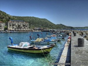
In a country as varied as Turkey it is very easy to describe an area as unique, but this description fits very well the mountains, coastline and valleys of the extreme north-east. The steeply-sloping northern side of the Pontic Mountains has always isolated this area from both east and west, and several different ethnic groups can be found today in the wooded valleys and coastal villages. Probably the most interesting of these are the Laz, a seafaring people who speak a language which is barely related to any other, except possibly Irish. Around Çamlihemsin, where we begin the trek, are a group of people who are famous throughout Turkey as confectioners, and in the hills are isolated pockets of Armenians and Georgians, some Christian, some Moslem, but still speaking their own languages.
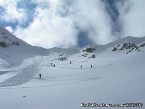
Each section of the Pontic range is known by its own name: the highest is the Kaçkar (pronounced Kachkar, the Turkish derivative of Caucasus) which rise to almost 13,000 ft. at Kaçkar Tepe. Much of the range is rugged granite and has been quite heavily glaciated - different scenery to that found in the Taurus, and particularly notable are the numerous small lakes found in the upper parts of the range. The contrast between the northern and southern slopes is quite dramatic, the former being green and, in places, heavily forested, while the latter can be quite barren. The lower northern slopes are very fertile, growing tobacco, tea, cherries and hazlenuts, and higher up there are extensive areas of rhododendron. Further up still, the hills are broken up by dramatic steep-sided ravines, making communication difficult and helping to preserve the distinct character of the different peoples. The grassy upper slopes, called ‘yaylas’, are covered in snow in winter, and in the summer the villagers move their herds up here for grazing - we will certainly meet many of these along the trek.
The people of this region lead a nomadic life, travelling with their cows and sheep between the lower valleys and high pastures, where they live for three or four months each year, pursuing a way of life that has remained unchanged for centuries. The woman wear brightly colured scarves turban-style. In the mountain villages, one senses their love of life and excitement, with singing and music of bagpipes. While it may sound like another traveller’s tale, it is infectious and difficult to resist joining in an evening's dancing when invited.
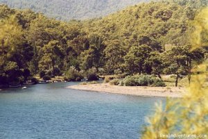
The Kackar rise beetween the shores of the Black Sea to the north and the river Coruh Valley to the south. On the northern flank, a good variety of vegetation flourishes in the rainy climate. Up to 500 metres above sea level, tea plantations and citrus orchards cover the hillsides. Chestnut, hornbeam, beech and other plantations are also present. Today there are more than 100 lakes on both sides of watershed, every valley bottom of this region contains a rushing stream and waterfalls.
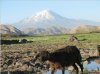
The earliest mountain ascent in the world of which any record has been preserved is the ascent of Mt. Ararat by the Patriarch Noah. Mt. Ararat is located in eastern Turkey near the Russian and Ä°ranian borders. As the crow filies, it is about 250 km. East of Erzurum, 130 km. Southeast of Kars and 160 km. Noth of Van. Mt. Ararat is a magnificent sprawling dome whose snow covered summit is 5165m. Above sea level. Most christians belive it is the site where Noah’s Ark came to rest after the “Great Floodâ€. A climb of Mt. Ararat is a tough walk ( non-technical but requiring a good deal of staminal). The upper third of the volcano is covered in snow and the last hundred meters to the summit is icy.
 (enlarge)